
Sewall’s Point waterfront planning
Seawall and dock planning in the Town of Sewall’s Point: riparian setbacks, the 200-sq-ft platform limit, courtesy notices, road flooding and CRS Class 10.
Describe your project on this page ↓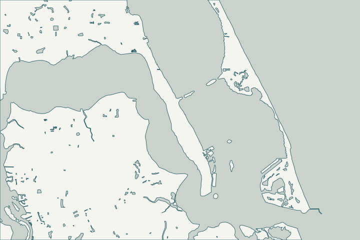
Get to know your waterfront
The Town of Sewall’s Point has more water than land inside its limits (about 2.95 square miles of water to 1.18 of land), with the Indian River Lagoon on one side and the St. Lucie River on the other. Its 2018 funding request called South Sewall’s Point Road the only evacuation route for 730 homes.
TIGERweb current Places layer (AREALAND, AREAWATER fields, converted from square meters) · Local Funding Initiative Request FY2018-19 #2367: South Sewall's Point Road Project
Water on both sides
Low road elevations flood in storms and king tides; the town has sought to raise South Sewall’s Point Road three feet. During Nicole, waves surged over the seawall at the south end of the peninsula. The lagoon side is in the Jensen Beach to Jupiter Inlet Aquatic Preserve.
The town is in CRS Class 10, meaning no community flood-insurance discount. Local Funding Initiative Request FY2025-26 #3460 (and FY2024-25 #3060) · IMAGES: Tropical Storm Nicole's impacts in South Florida · Jensen Beach to Jupiter Inlet Aquatic Preserve · CRS Eligible Communities, October 1, 2026 Effective Date
What could the work cost?
Ask for cap-elevation and drainage options in any replacement scope; flooding here comes over the cap and up through drains.
Published examples are attributed context from Treasure Coast and nearby South Florida sources, not a Port St. Lucie average or a quote. Your wall needs a property-specific written scope.
Compare quotes and plan a budget →Find the relevant permits and records
| Starting point | What to resolve | Prepare and look up |
|---|---|---|
Town of Sewall’s Point Building Department | Town permit for docks, lifts and shoreline work. | DEP permit or exemption, sealed drawings, mean-high-water survey, riparian setbacks. 772-287-2455. |
FDEP and Army Corps | State exemption or permit and federal authorization. | FDEP Southeast District: 561-681-6600. |
FDEP state lands (Indian River Lagoon preserve) | Consent to use state-owned bottom land in an Indian River Lagoon aquatic preserve. | Docks limited to 500 ft or 20% of waterbody width; access walkways 4 ft wide. |
A Sewall’s Point checklist
Use these steps to gather records and prepare a property-specific conversation. Public records and project references do not describe the condition of your wall.
Pull the permit history
Search the address on the city or county permit portal for seawall, dock and lift permits and their final inspections before the first site visit.
Check riparian setbacks
Docks need 25-foot riparian setbacks and 50 feet to neighboring docks.
Notify neighbors on canals
Canal docks need letters of no objection or courtesy notice.
Record the NOC
A recorded Notice of Commencement is needed for work of $2,500 or more.
Get help with your Sewall’s Point seawall
Tell us what has changed and how to reach you. We’ll help you work out the next step; photos and measurements can follow later.
Sewall’s Point project questions
How big can a dock platform be?
The town’s checklist limits the terminal platform to 200 square feet.
Does Martin County permit Sewall’s Point?
No; the town has its own Building Department.
Keep planning
Nearby waterfront guides
Stuart, Jensen Beach, Port Salerno & Manatee Pocket, Sailfish Point
Show sourcesHide sources
- TIGERweb current Places layer (AREALAND, AREAWATER fields, converted from square meters)Source reviewed 2026-10-25
- Local Funding Initiative Request FY2018-19 #2367: South Sewall's Point Road ProjectSource reviewed 2026-10-25
- Local Funding Initiative Request FY2025-26 #3460 (and FY2024-25 #3060)Source reviewed 2026-10-25
- IMAGES: Tropical Storm Nicole's impacts in South FloridaSource reviewed 2026-10-25
- Jensen Beach to Jupiter Inlet Aquatic PreserveSource reviewed 2026-10-25
- CRS Eligible Communities, October 1, 2026 Effective DateSource reviewed 2026-10-25
- Dock / Boat Lift Permit Application and ChecklistSource reviewed 2026-10-25
- Southeast DistrictSource reviewed 2026-10-25
- Reissuance and Modification of Nationwide PermitsSource reviewed 2026-10-25
- Florida Statutes s. 258.39 - Boundaries of preservesSource reviewed 2026-10-25
- Fla. Admin. Code R. 18-20.004 - Management Policies, Standards, and CriteriaSource reviewed 2026-10-25
- Fla. Admin. Code R. 62-302.700 - Special Protection, Outstanding Florida Waters, Outstanding National Resource WatersSource reviewed 2026-10-25